The origin of its name is believed to be a combination of Georgian (“kob”) and Armenian (“aiyr”), word roots for cavern—indeed, the surrounding hills are full of caves. Kobayr was an important center of writing and culture in the mid. 13th century. The complex is composed of the Main Church/Katoghike, Mariamashen Church, belfry/sepulcher, the ruins of the 13th century refectory and the remains of a 12th century single-nave church. The main church, the late 12th century Katoghike is a partially ruined single nave church that is undergoing restoration. The church’s most famous features, though, are the magnificent frescoes that are still preserved.
DILIJAN
Usually called Armenian Switzerland or Little Switzerland by the locals, it is one of the most important resorts of Armenia, situated within the Dilijan National Park. The forested and reclusive town is home to numerous Armenian artists, composers, and filmmakers and features some traditional Armenian architecture. The Sharambeyan street in the centre, has been preserved and maintained as an “old town”, complete with craftsman’s workshops, a gallery and a museum. Hiking, mountain biking and picnicking are popular recreational activities.
LCHASHEN
Lchashen village is located in the northern end of the Geghama Mountains. The excavation site of Lchashen is one of the most important archeological sites uncovered in Armenia. The ancient necropolis was discovered in 1950 when Lake Sevan’s water dropped due to hydroelectric production and covers a surface of 800 x 100 meters. At the southern edge of the necropolis there is a cyclopic fortress and an ancient settlement.
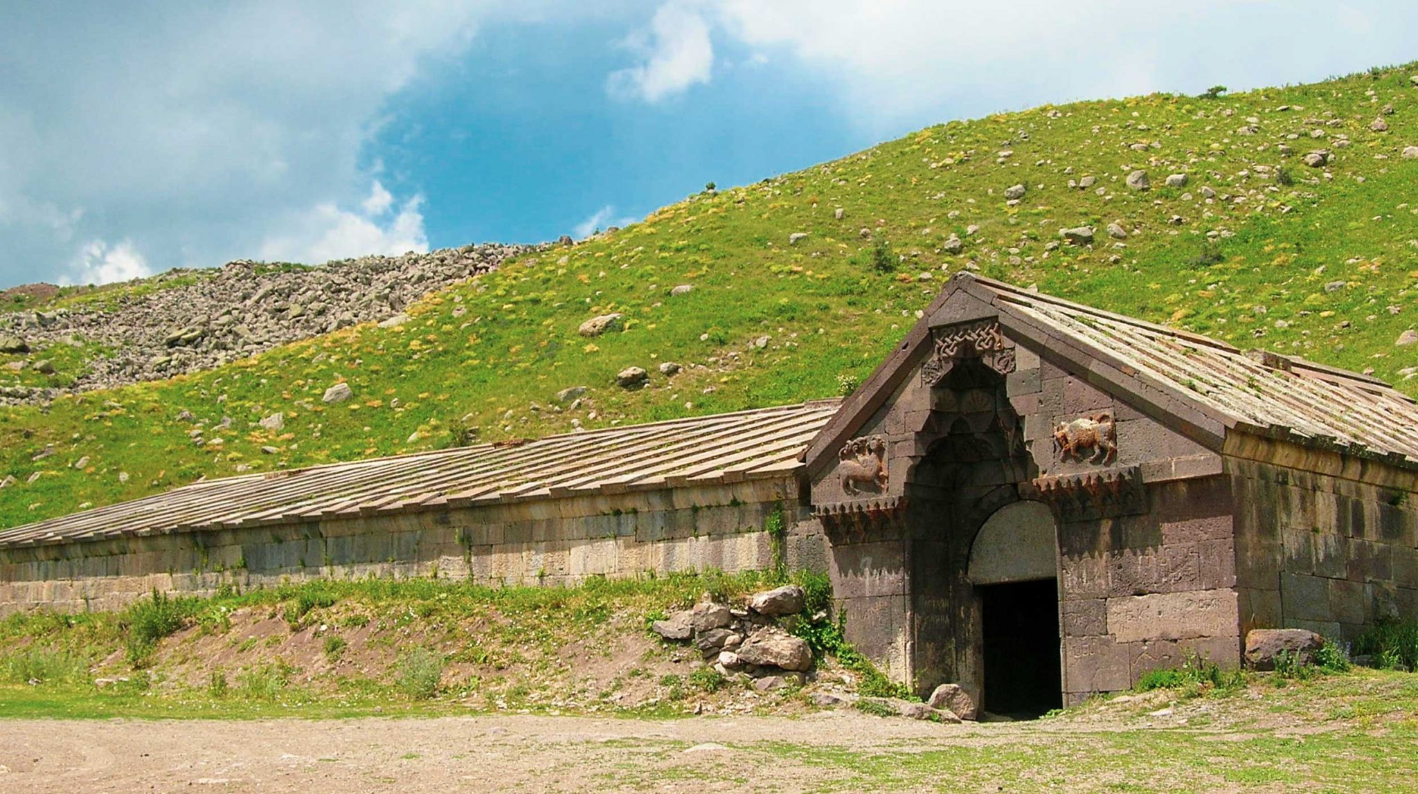
SELIM CARAVANSERAI
The caravanserai of the Selim Pass (1326) is one of many in Armenia. These were served as overnight accommodation for caravans charged to Europe and the East. Many think that the Silk Road is just one street, but in reality there were so many ways that connected the East with the West, some by land, some by sea. These links crossed into Armenia and linked the East with the West, the South with the North. The most used roads passed through the valleys near the rivers and lakes. The caravanserais, where they found lodging the caravan components and their loaded animals, indicated the route of the Armenian Silk Road. The caravanserai of the Selim pass is the best preserved one.
MOZ
Originating in the Bronze Age, the settlement of Moz benefited by its location above the right bank of the Arpa River, inside what was then a rich natural area, with lush forests and a gentle climate. Moz was a famous trade center even in medieval times. The loss of the forests has resulted in the desert terrain you see now. Today almost nothing is left of historic Moz, the result of a massive eruption that obliterated a once thriving metropolis and important stop on the Silk Road network. The city may be lost, but the ancient path is still used by modern “caravans”, large semi-trucks plying the trail from Iran to Georgia.
TATEV MONASTERY
Tatev Monastery is a complex surrounded by massive walls located in the south-east of Armenia, not far from the town of Goris. It was founded in the 9th century and soon after that became the political centre of Syunik. The story tells that the architect of the monastery once finished the dome of the main church could no longer go down. He shouted: “Astvats eents ta-tev”, which means “May God give wings”. That was how the monastery got its name: Tatev’s strategic position, perched on the top of a steep ridge, made access to the enemy almost impossible, even today, accessing the mighty fortress is a real challenge.
HALIDZOR BERD
The fortress of Halidzor is a renovation of an early 17th century complex which was also known as Halidzor Convent/Hermitage. Its location made the site impregnable from attack, and this drew its attention to the early 18th century freedom fighter Davit Bek, who used it to defend the region and who, along with 300 volunteers, moved into the fortress in 1723 and faced a seven day siege by an invading army of 70,000 Ottoman Turks. Among the features of the fortress, a secret tunnel was dug that ran 500 meters to the river to allow inhabitants to draw water. The complex includes a separate church to the east. Its architecture is plain, the builders using old techniques of masonry and hard stone. The same technique was used to build the fortress complex, including the main church St. Minas.
ODZUN CHURCH
Odzun Church is an Armenian basilica constructed around the 5th – 7th century in the Odzun village of the Lori province. This is the time the church got its current form of a pink felsite basilica with three naves, the two side naves being narrow. At the northern (not preserved anymore) and southern side there are unusual arcaded cloisters and the west cloister has a blind wall with an arched entrance in the middle. There are numerous gravestones of the clergy around the church, as well as a funerary monument. Its stepped platform supports two carved stelae, each within one of a set of double arches. The east and west sides of the monument are carved with scenes from the Bible and introduction of Christianity in Armenia. Its north and south side are carved with geometrical motifs and floral shapes.
FIOLETOVO
Fioletovo is a village in the Lori Province. It was known as Nikitino until 1936, when it was renamed Fioletovo in honour of the Russian Communist activist and one of the 26 Baku Commissars Ivan Fioletov. In the 1840s the villages was settled by Spiritual Christians relocated from Russia. Today it is inhabited by 3 congregation of Dukh-i-zhiznikiand one congregation of Molokane. The village has an extremely cold winter with a cool and mild summer. It lies under a thick layer of snow during the long winter season, where only the roofs of houses could be seen from the top with their smoking chimneys.
SEVANAVANK
Sevanavank is a monastery located on the northwestern shore of Lake Sevan in the eastern part of Armenia. It was founded in 874 AD from Princess Mariam, the daughter of Ashot I, who became the king after a decade. Jean-Marie Chopin, a French explorer from the Caucasus, visited Sevanavank in 1830 and reported that the monks led an extremely ascetic lifestyle. Another explorer visited the monastery in 1850 and reported that the manuscripts were still copied by hand. Thanks to the improved accessibility (once it became a peninsula), good road and rail connections with Yerevan, to well-developed tourism in the city of Sevan and its picturesque location, Sevanavank is one of the most visited sites in Armenia.
NORADUZ
Noraduz is a cemetery with a huge collection of ancient khachkars (crosses carved in stone) near Lake Sevan. It represents the largest existing khachkar cemetery in the Republic of Armenia. The oldest khachkars in the cemetery date to the 10th century. Many of them are from the 16th and 17th centuries. Many stories are told about the Noraduz Cemetery. According to a popular legend, when the army of Tamerlane invaded the area, the villagers put helmets on top of the khachkars and supported swords. From a distance, the khachkars appeared as strong and robust armed soldiers, that discouraged Tamerlane and his army to the point of inducing them to withdraw.
YEGHEGIS
Medieval Yeghegis was one of the richest cities in Armenia and seat of the Orbelian (Proshian) family in the 13th-14h centuries. Ruined during earthquakes, the city was abandoned by Armenians forced into exile into Persia and renamed Alayaz by later inhabitants. The village was renamed Yeghegis after its original name. On entering the village, you pass two monuments. The one on the right is the covered 12th-13th century great khachkar (stone cross), encased with a peak roof. Another khachkar is on the left, opposite the stone mill. The triple nave Astvatsatsin basilica was rebuilt in 1703 using stone blocks from earlier periods. The 13th century St. Karapet is a well preserved domed cruciform church. Zorats Church is located at the east end of the village. The village center has the scant remains of an ancient katoghikeh (cathedral), dating to the 10th century. Across the river, reached by taking a lower road to the site across the bridge is Yeghegis Jewish cemetery. The 13th century graves attest to a vibrant community in Yeghegis at the height of Orbelian-Proshian power.
STONEHUNGE
Of particular interest is the ancient observatory Zorats Karer, Karahunge or Armenian Stonehenge, which are the testimony of one of the oldest civilizations in the world. This menhir complex occupies an area of about 7 hectares, extended for more than 300 m height at about 1800 m above the sea level and remotely recalls the tidy lines of titans. All the stones of the monument are of basalt and some have slits. The megalithic site would be an ancient observatory that was used to follow the movements of celestial bodies and to measure time. Stonehenge has been compared with Stonehenge Carnac and Newgrange.
PETROGLYPHS OF UGHTASAR
Ughtasar, “the Mount of the pilgrimage” (Ughtasar is also called the “camel” mountain, due to its characteristic shape), is a spectacular, extraordinary and unique place in Armenia. The scenery of Ughtasar, of volcanic origin with glacial lakes, green meadows and mountain tops, gives visitors an extraordinary feeling of isolation from city life. The site is a wonderful refuge for those who would like to retire for one, two or more days, in or without a tent. Thousands of prehistoric petroglyphs, dating to the 5-2 millennium BC, surprise the visitor with their rich variety of forms and motifs: human depictions of Bezoar goats, chariots, panthers, abstract images and anthropomorphic representations of Shamans.
GORIS
The city of Goris is located in a gorge carved by the Vararakn River at 1400 m above sea level. The area has a number of needle-stone formations that make up its unique geographic relief. The area was settled in the prehistoric period. The first settlers used the area’s extensive cave system. Artifacts include obsidian and basalt flakes and a large number of bifacial tools and weapons. Ceramic pottery and other objects, plus large tomb fields date to the Copper and Bronze Ages. In the 17th-18th centuries Goris was one of the landholdings of the rich and powerful Melik Huseniants family. The modern town (right bank) was founded in 1870 as the administrative capital of a new Zangezur district on the Russian province of Elizabetpol, reaching city status in 1885. Goris is characterized by straight streets and houses of basalt and tufa, but the high rocks, the pyramidal peaks, the deep gorges, the caves give a special aspect to the city.